Garmin Oregon 650T Mapping Handheld GPS Unit
The rugged and waterproof Garmin Oregon 650T GPS cycling computer will get you riding ahead of the pack with accurate performance data, in real-time. A 3" sunlight readable touchscreen display ensures you'll always to see your data at a glance.
Explore and discover new places with a Europe recreational map with shaded relief, terrain contours and points of interest.
Not just a cycle computer, the Garmin Oregon is equipped with a 8 megapixel, autofocus camera with integrated torch. A 3-axis compass ensures you'll stay on the right track while accelerometers and barometric altimeter sensors offer pin point accurate data.
A dual battery system lets you switch between 2 AA batteries or the included rechargeable internal NiMH pack. This doubles your battery power so you don't lose data.
More Features, More Satellite Power
The new rugged and waterproof GPS Oregon series – more features, more power and the most brilliant, sunlight readable touchscreen we’ve ever put on a Garmin handheld.
From the moment you cradle the 650t in your hand, you’re ready to enter into a bold new world of Garmin outdoor navigation. With high-sensitivity GPS and GLONASS satellite tracking (more satellites mean faster fixes, even in challenging environments), preloaded European Recreational Map with shaded relief and a faster processor, you don’t just look at maps, you intuitively interact with them. Zoom in, pan out and rotate using multi-touch in any conditions and even with most gloves. The reflective display technology boosts touchscreen brightness so much that maps and displays are as vivid in full bright sunlight as they are in shade. And, mark memories with an 8 megapixel autofocus camera with digital zoom and automatic flash/torch, plus customisable quick access buttons for 1-touch image capture and waypoint marking.
Touch and Go
Oregon 650t was purposely engineered for the outdoors. It features the most brilliant, sunlight readable touchscreen we’ve ever put on a Garmin handheld, strengthened for impact resistance but with multi-touch and dual orientation views that still accommodate gloved operation. Bumps, dust, dirt, humidity and water are no match for this mapping-oriented navigator.
Explore the Terrain
Oregon 650t comes preloaded with the European Recreational Map and a worldwide basemap with shaded relief — all the tools for outdoor travellers throughout Europe. Map detail includes roads, forests, terrain contours, elevation information and many points of interest.
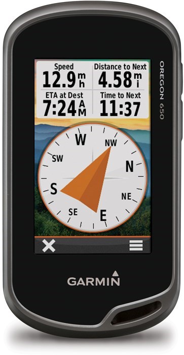
Get Your Bearings
Oregon 650t has a built-in 3-axis electronic compass with accelerometer tilt compensation, which shows where you're heading even when you’re standing still, and not holding it level. Its barometric altimeter tracks changes in pressure to pinpoint your precise altitude, and you even can use it to plot barometric pressure over time, which can help you keep an eye on changing weather conditions. And with its high-sensitivity, WAAS/EGNOS and GLONASS-enabled GPS receiver and HotFix® satellite prediction, Oregon 650t locates your position quicker and more precisely and maintains its GPS location even in heavy cover and steep sided valleys.
Double Your Power
Besides its outstanding performance of up to 16 hrs of battery time the new Oregon 650t features our outdoor optimised dual battery system. You’ll have the option of using the internally rechargeable NiMH pack (included) or traditional AA batteries in case there is no opportunity for charging — The NiMH pack charges automatically whenever the device is connected to external power.
Quality Photos
Now you don’t have to take an additional camera with you to take quality photos. Oregon 650t's built in 8 megapixel autofocus digital camera takes photos worthy of sharing. And each picture is right away geotagged with the location of where it was taken, allowing you to navigate back to that exact spot in the future. Then share the photos from your Oregon 650t via USB with all your friends through Garmin Adventures, the new online adventure sharing community. For more storage, insert a microSD™ card; you can even view pictures from other devices with Oregon's picture viewer.
Share Wirelessly
Now you can wirelessly transfer large files such as photos, geocaches, routes and Custom Maps between Oregon 600-series devices. Plus, new technology allows your routes, waypoints and tracks to transfer up to 50 times faster. Oregon is also ANT+ wireless compatible with heart rate, chirp and tempe sensors.
Add Maps
Adding more maps to Oregon is easy. Load our Garmin GB Discoverer™ Ordnance Survey® 1:50k maps or choose our Birdseye™ Select 1:25k Ordnance Survey maps and hit the trail. Plug in BlueChart® g2 preloaded cards for a great day on the water or load City Navigator map data for turn-by-turn routing on roads (see maps tab for compatible maps). Add satellite images to your maps with Birdseye™ Satellite Imagery (subscription required).
You can even display and enter coordinates in British Grid format, the grid used on Ordnance Survey maps.
Load All the Geocaches
No more picking, choosing and planning, just download them all. The Oregon 650t can hold a massive number of geocaches. Not just one thousand, not just one million. Four million. Download caches from geocaching.com. Load caches from GSAK. Or use your favourite program or website supporting GGZ files*. All your paperless geocaching features will be there for every cache. Read full descriptions, hints and logs. Filter caches by size, terrain, difficulty and type. Connect to chirp-enabled caches. Record your logs in the field. Do it all. The Oregon 650t has no limit.
Plan Your Next Trip
Make the most out of your adventures with BaseCamp™, Garmin's free trip planning software. BaseCamp is the perfect environment to comfortably prepare your trips with maps, waypoints, tracks and routes before you get out and once you are home again to create amazing Garmin Adventures to share with friends, family or fellow explorers. The software displays topographic map data in 2-D or 3-D on your computer screen, including contour lines and elevation profiles.
Create and Share Adventures
Garmin Adventures provides a free, interactive way to share your hikes, bike rides, road trips and more. Using BaseCamp, you can combine track logs, waypoints, geotagged photos, YouTube® videos and more into an adventure that gets published online. You can then email a link to your adventure to friends and family, share it on social media sites or even post it in your favourite forums. BaseCamp even makes it easy to follow in the footsteps of other travellers by allowing you to search for and download adventures.
Display Brightness
Reflective display technology uses external light, such as sunlight, in combination with the device’s LED backlight to increase brightness and viewing. Plus, you conserve power by not having to turn the backlight up.
Dual Orientation
View maps and data in portrait or landscape mode. Landscape mode is great for typing and road navigation.
Advanced Elevation Plot
Full Track view lets you see the entire elevation plot and quickly move your zoomed view to any place on the plot. Future Plot uses your mapping data to show what to expect ahead.
Improved Trip Computer
Get 33 percent more data on screen at once with new layout options. Add multiple pages of data fields, each customisable to 1 of 4 layouts: 2 large, 1 large and 4 small, 6 small or 8 small.
Activity Tracking (Calendar)
Track your accumulated activities, waypoints and geocaches; tracks on the day you do them.
Advanced Waypoint Management
All data is displayed and editable on one screen. Delete one or multiple waypoints at a time from the Waypoint Manager menu.
Wireless Capable: Bluetooth® and ANT
Now you can wirelessly transfer large files such as photos, geocaches, adventures, routes and Custom Maps between Oregon 600-series devices. Plus, new technology allows your routes, waypoints and tracks to transfer up to 50 times faster. Oregon is also ANT+ wireless compatible for heart rate, cadence, chirp™ and tempe™ sensors.
Shortcuts
Launch apps, switch Profiles, apply settings and start navigating with one touch.
Dashboards/nüvi® Mode
Dashboards let you hide and show more functions to your favorite app. With this at-a-glance information, you can multi-task without having to disable the app.
*iphone 4s or newer
Garmin Oregon 650T GPS Key Features
- GPS/GLONASS satellite for accurate satellite tracking
- Built-in worldwide base map with shaded relief give you all the tools for serious climbing or hiking
- 3-axis compass, accelerometer and barometric altimeter
- Wireless sharing via Bluetooth or ANT
- Multi touch with pinch to zoom
- Portrait and landscape orientation
- Advanced elevation dynamics and Future plot shows you what has been done and what is coming up
- Improved user interface with profiles
- Can hold up to 4 million Geo caching points!
- Dual power battery device
- Either use AA or the rechargeable batteries
- IPX-7 waterproof
- Comes with an 8mp digital camera and torch
- Unit dimensions (cm) - W x H x D: 5.8 x 11.4 x 3.5
- Display size (cm) - W x H: 3.8 x 6.3 - diagonal: 7.6 cm
- The Oregon unit is not equipped with a bike mount, please also see GMS014
What's in the box - Oregon 650t
- Oregon 650t
- Preloaded European Recreational Map
- NiMH battery pack
- USB/charging cable
- AC adapter
- Carabiner clip
- Quickstart Guide
Specification
Physical & Performance |
|
| Physical dimensions | 2.4" x 4.5" x 1.3" (6.1 x 11.4 x 3.3 cm) |
|---|---|
| Display size, WxH | 1.5"W x 2.5"H (3.8 x 6.3 cm); 3" diag (7.6 cm) |
| Display resolution, WxH | 240 x 400 pixels |
| Display type | transflective color TFT touchscreen |
| Touchscreen | Yes |
| Weight | 7.4 oz (209.8 g) with batteries |
| Battery | rechargeable NiMH pack (included) or 2 AA batteries (not included); NiMH or Lithium recommended |
| Battery life | 16 hours |
| Water rating | IPX7 |
| High-sensitivity receiver | Yes |
| Interface | high-speed USB and NMEA 0183 compatible |
| Camera | yes (8 megapixel with autofocus; digital zoom and flash) |
| Barometric altimeter | Yes |
| Electronic compass | Yes (tilt-compensated 3-axis) |
| Unit-to-unit transfer (shares data wirelessly with similar units) | Yes (plus images and custom maps) |
Maps & Memory |
|
| Basemap | Yes |
|---|---|
| Preloaded maps | yes (topographic) |
| Ability to add maps | Yes |
| Built-in memory | 4.4 GB |
| Accepts data cards | microSD™ card (not included) |
| Custom POIs (ability to add additional points of interest) | Yes |
| Waypoints/favorites/locations | 4000 |
| Routes | 200 |
| Track log | 10,000 points, 200 saved tracks |
Outdoor Features |
|
| Automatic routing (turn by turn routing on roads) | Yes (with optional mapping for detailed roads) |
|---|---|
| Geocaching-friendly | Yes (Paperless) |
| Custom maps compatible | Yes |
| Hunt/fish calendar | Yes |
| Sun and moon information | Yes |
| Tide tables | Yes |
| Area calculation | Yes |
| Picture viewer | Yes |
Additional |
|
| Additional |
This USB mass storage device is compatible with Windows® XP or newer and Mac® OS X 10.4 or later. |
|---|---|
Occasionally, without notice, manufacturers change product design and/or specifications.
Customer reviews and Q&A's are disabled because you declined functional cookies.
To enable reviews and Q&A's click the 'Cookie Settings' button below and enable functional cookies.
No longer available
Sorry you missed the Garmin Oregon 650T Mapping Handheld GPS Unit.
This product is no longer available.